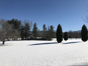
We start out the first week of 2017 with a moderate snowstorm followed by plunging temperatures hovering a few degrees above or below zero depending on the elevation….Brrrrr! The temperatures will be warming up pretty quickly this coming week and we surely can’t complain much about them so far this fall and winter. Other than the smokey skies from the fires in November, the weather has been really good if you’re into lots of warm sunshine.
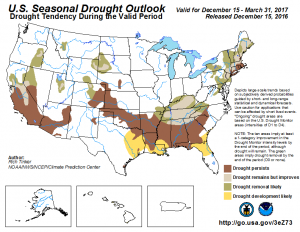
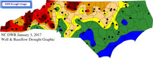
As a golfer and a hiker, the weather has been fantastic, but the need for precipitation is very apparent to me when playing on the area golf courses. Despite some recent rain and this weekend’s snowstorm, we are still in a severe drought classification in Haywood County and most of the western mountain region of North Carolina (NC drought map).The area rivers, creeks, and waterfalls are noticeably low-flowing, but where the drought is most obvious is along the Little Tennessee River near Bryson City and along the shores of Fontana Lake. Just like bathtubs you can clearly see the low water levels on these waterways.
There seems to be no consensus among forecasters about the severity and persistence of drought conditions into 2017, so we can only hope and pray for wet skies. Cataloochee Ski Area in Maggie Valley possesses state-of-the-art snowmaking equipment, but real, drought reducing snow is much preferred over man-made snow. Heavy snow and rain produces full rivers and reservoirs which power spring and summer outdoor sports and fisheries that the Western North Carolina economy relies on to drive tourism.
As with all cycles, there is ebb and flow, and most certainly the rain will return. Golfers will walk on lush, green putting greens and fairways, fisherman and kayakers will venture into fast flowing rivers, and skiers and snowboarders will thrash fresh, heavy powder again. Let’s just hope that comes in 2017.